Contents
Background / Prep
There have been other posts about this ride, the thinking behind it and the job of getting the ride approved by the IBA. – I’ll not cover that same ground again here, this is intended to be a ride report and to go a little into the preparation for the ride itself, how we approached this level of challenge and what it was like to actually do it.
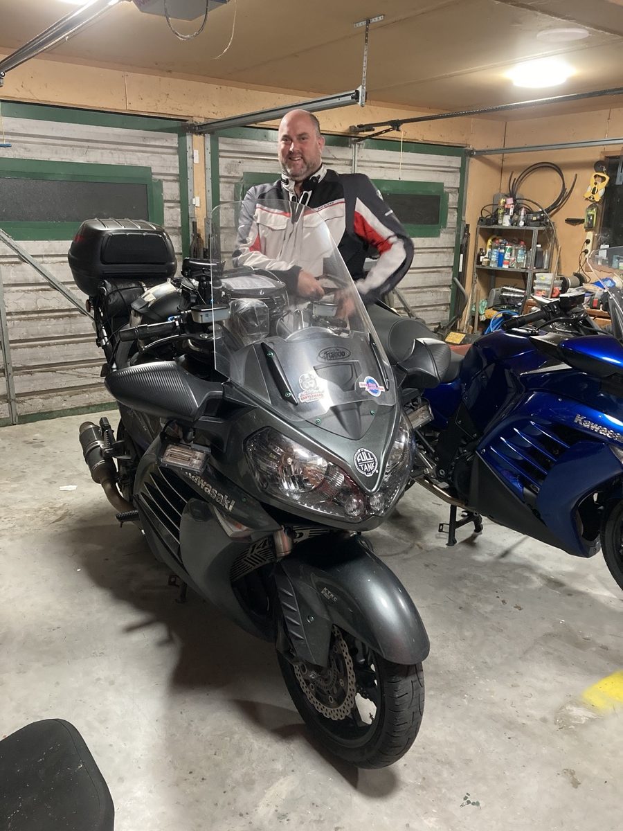
I knew from about mid-December that I would have to set aside some time in January to get out and prove this ride could be done as planned. This was in part due to the coordinated effort which had begun between Julian and myself to see whether we could do one Island each and have the two rides certified within a few weeks of each other; the idea being to bring about a new set of ride certificates for others to do. This timeline didn’t leave me much time to do any specific preparation and thankfully, the bike (a 2015 Kawasaki Concours) was already fully prepared and ready to go.
I had a fair bit of preparation in terms of planning to do, because both rides needed to be fully enough documented, so that both Julian and myself could follow the intended routes, gather the intended checkpoints, take our own sets of checkpoints photos etc and importantly see if the timing allocated for the riding distance was both reasonable and achievable. Julian had managed to set his own ride date first, on the Summer Solstice, so planning that ride took precedence over my own. I knew that I wouldn’t get a chance to head out to do this until the first soft week back at work, the week starting the 5th January.
As you’ll likely have read Julian had a hard time with a puncture on this first attempt and would also have been hit with some pretty miserable weather on the 22nd Dec, had he continued to ride. He was able to give this another go before my own attempt, starting on the 1st Jan, 2021. This too got his by really poor weather…
So over Christmas, I was getting quietly excited knowing what was in the wings, I don’t think that many people were aware of what we were embarking on, even with Julian’s double attempt at his thing. We were socialising with people over the Christmas period and those closest to me got to hear of my mad plans and what we were up to, but in general it wasn’t common knowledge. In part, because the IBA’s involvement in these types of things tends to happen *after the ride* has been done and normally there’s very little before; and until you’ve got that formal tick and endorsement, there’s kind of not that much (apart from it just being an idea), to talk about.
We had some friends staying with us over the late Christmas and New Year period; they left on the 2nd and so that really defined the potential window for me, in terms of when I could do this ride. A combination of both a really decent 2-day window in the weather, along with those same days coinciding with when some people would be starting back at work, made me think that the choice of the 5th-6th January 2021 would be an ideal choice to try to do a 3,300km+ ride.
So, here’s the first thing which I deliberately did in the way of prep: after my friends left, on the nights of the 2nd and 3rd of January, I made sure I went to bed early and took some melatonin to ensure that I was getting the best possible sleep for these nights, leading up to my departure. (I’ve had this for year, bought in the USA, it’s not something you can get here in NZ, you can buy it in Aus… – I’ve found this works pretty well for me when I need it, it’s not often or regularly that I will take this). I had also been drinking a lot of fluids over that same timeframe to make sure that I was properly hydrated before I started the ride and I’d knocked off any caffeine for the previous 4 days – to help me to sleep better on the run up to the ride.
The bike got a fresh oil change, both engine and final drive, it had already had some new rubber on it, so it was ready. I made an orderly list of things I needed to do before the ride, things like making sure the battery packs were all charged, things to pack into my tank bag which don’t already permanently live on my bike… The run up to this ride was calm, not-stressed, well planned.
Talking of planning, this was an area where I didn’t know exactly what to do; normally for a 1600K ride, I would be happy to plan the whole ride, down to the minute, I’ve got my route planning approach in BaseCamp sorted, I take the outputs of that, into my own Excel based summary file, lay it all out, with the leg distances, times, stop-over durations, fuel stops, fuel legs etc etc; it summarises my average speed per leg (which was provided by BaseCamp) and normally at this point, I run through it, leg by leg and apply what I know of each leg, to then manually adjust the avg speeds for each leg – to end up with, what is normally a really accurate and achievable plan across the whole ride. Normally, when it comes to riding the plan, we’re within minutes of the plan and often make gains at the planned stops when we don’t need to take the whole time allocated at each stop.
Normally I’d prefer to plan slightly slower and then be ahead of the plan on the ride. There’s nothing better than hitting a stop and being able to say ‘we’re 12 minutes ahead’, so we can relax at this one and take our time…
This time, things were slightly different. Primarily because I didn’t know (through my own personal lack of experience at multi-day long distance rides) how I would approach those distances after the first 1600km. I didn’t know if I would be best to plan a sleep stop, or simply plan to ride on, until I felt the need to sleep, then stop and find somewhere (IBA motel style).
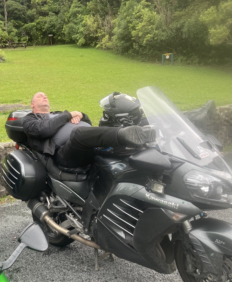
The IBA motel. – Anywhere you can grab a few winks…
My 1640km point was at Whanganui, where my good friends Al and Beks live. They were also the friends who were staying with us over Christmas so I’d made some flexible arrangements with them that I could stop in on the ride if it would help. Beyond planning for the possibility of a stop, I’d spoken to others about the likely best approach to take and the advice I got back was as divided as I had been myself over this: Someone, experienced in multi-day rally riding told me that for something ‘short’ like a 2-day ride, it doesn’t matter what you plan, as long as you listen to your body and react appropriately, making sure you’re safe when you’re riding and not to fall asleep on the bike. Others, who were perhaps being more cautious were telling me to plan a stop and plan some sleep…
Myself, I didn’t know how I would be feeling; I know from experience, that at the end of some of these rides, you’re buzzing and when you’re at the end of it, you feel like you could carry on for another four hours or so… I was planning to try to go my first 1600km within about a 20-20.5 hour pace if possible, so it seemed reasonable to me that there might still be some juice left in my tank at that point and if I was getting into Whanganui at, just after mid-night, then I might want to push on for 2-3 more hours, a little closer to the period which I personally tend to find the hardest, 4-6am.
While this might all sound trivial now, it really did become a bit of a sticking point for me, call me OCD, but I like to have a known plan. I’m a big fan of the ‘plan your ride, ride your plan’ mantra. This was actually causing me a degree of consternation and it was getting in the way of me feeling settled about finishing off my plan. How then, do I get over this (small hurdle) and settle things so that I can take my common, comfortable and already proven approach? The answer was I couldn’t… I just had to find a way to be OK with it.
… What helped was the idea of ‘going for certificates’… It’s possible within certain, longer IBA rides, to nest other, smaller certificates within them, there are rules around this which I’m not getting into here, but suffice it to say, you can sometimes do it. So, I had planned to aim for the following certificates during this ride, in the following order of completion.
- SaddleSore 1600K – ending in Whanganui, or beyond – wherever I got to within the first 24-hours.
- SaddleSore 2000K – a lesser known and lesser achieved certificate which demands a consistent riding pace and minimalist stops (which is what I would be doing anyway), also over 24-hours, this certificate has only been done once in NZ before, by Long John Silver. It’s something on my bucket list and to be honest, it’s one of those which you’ve either got to set out to deliberately do, or examine each potential opportunity when you’re doing other rides to see if it is the right time to push on for it. Since it’s also over a 24-hours period, it requires you to be on a 19.5 hour or better pace for your first 1600K and if you’ve got that sorted, then use the remaining 4.5 hours to complete the remaining 400km requirement… – That was my plan. If my pace throughout the first half of the ride, was quick enough into Whanganui, then I wouldn’t plan to stop there, but push on and see if I could end up with 2,000km.
- Bun Burner 1500 miles, or Bun Burner 2500K. – All within the first 36-hours of the ride, presumably.
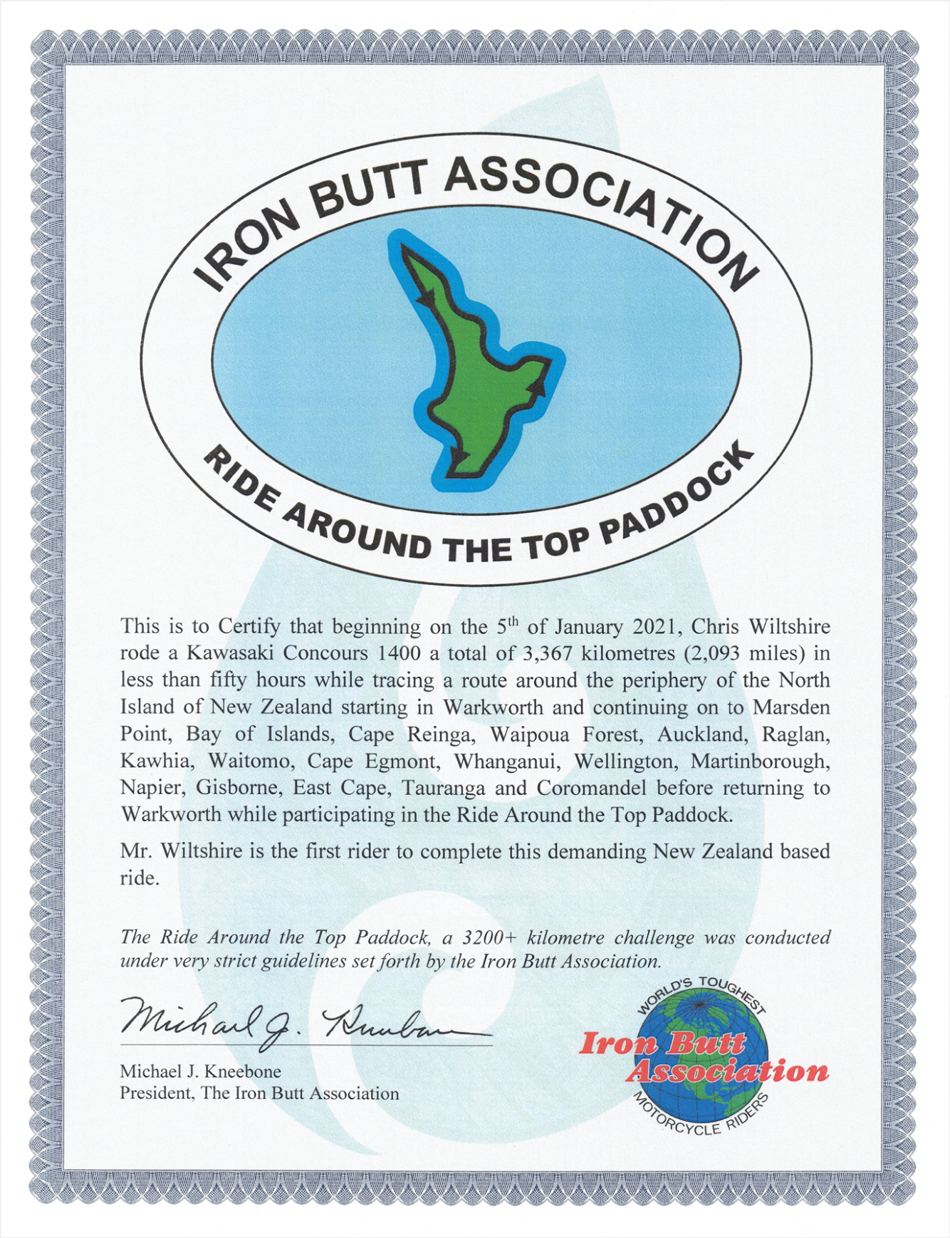
- SS3000K or ‘Ride Around the Top Paddock’ – whichever was going to be approved by the IBA.
With the SS2000K in mind, that *required* me to be flexible in my approach and my planning. – That settled my mind a bit; as justifiably I would need to leave that decision until I was out on the road. Not having to place ‘resting times’ in my plan was OK with me, as I knew then that the plan only contained ‘riding time’, without any ‘rest time’ and that I’d simply need to be able to do the mental arithmetic from the timing sheet as I rode round. This is how my planning sheet was printed and published, along with the note: “The timings assume no significant stoppage, which is completely unrealistic, but since I don’t yet know where I will want to stop, this is the best I can do in terms of planning currently… So, expect me to be running well behind these times. …”
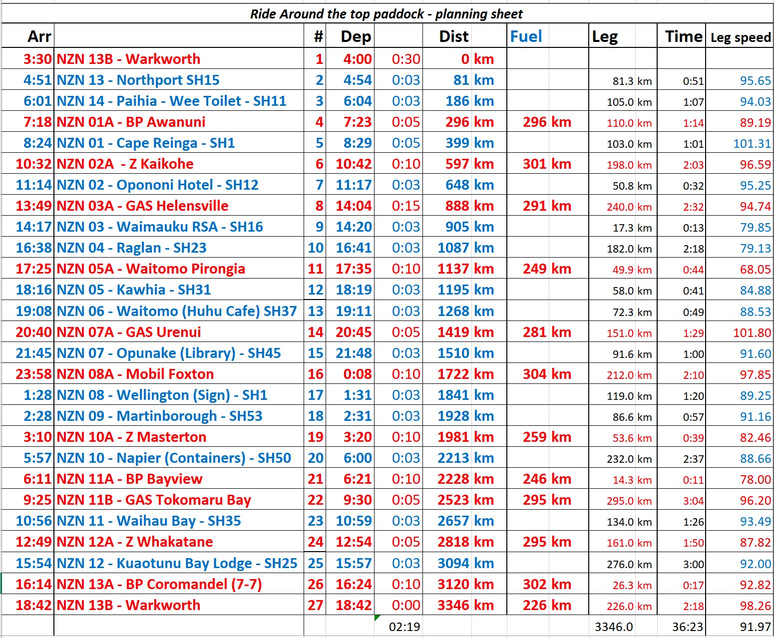
The other thing which I didn’t do, was to adjust the leg speeds from what BaseCamp had provided, as such I ended up with some unrealistic legs where the leg speed was shown to be average an excess of 100km/h – I didn’t ride at that pace, so these also added to me falling further behind the plan. – Not my finest planning work, but since the time estimates were going to be out anyway, I didn’t worry about it. It was printed and laminated and in my tank bag before I had noticed I’d forgotten to adjust those leg times, so I let it go.
I might write another post about ‘things to pack / prep / take with you’ on the bike since I’ve been asked to share some of that insight.
The ride
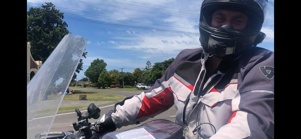
Anyway, now you know what I had planned, how I was approaching the ride and how I had planned to approach the decisions around when and where to sleep. So, on my final night before the ride, on Monday the 4th January, I went to bed at about 8:30pm, all packed up and ready to go. I stayed well away from the melatonin on this night as it can take a while for the body to shake it on a normal morning; there is no way that I wanted to be setting out groggy on the ride. I surprised myself, I managed to fall asleep quite quickly and slept right through, until my alarm at 2:50am.
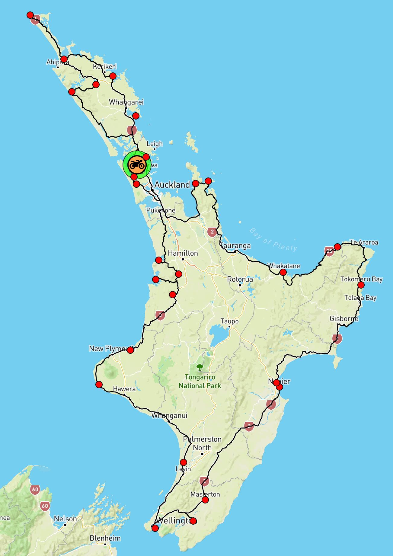
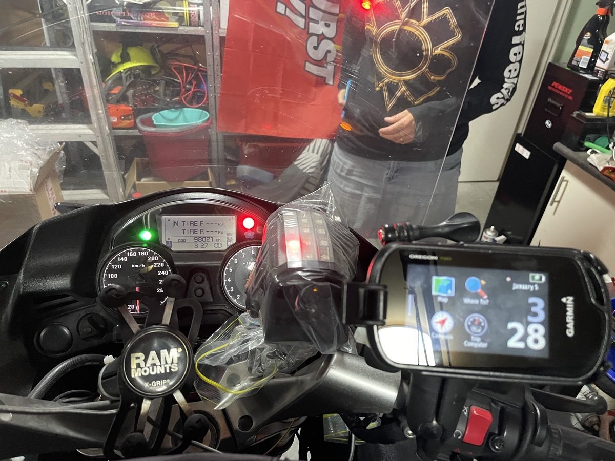
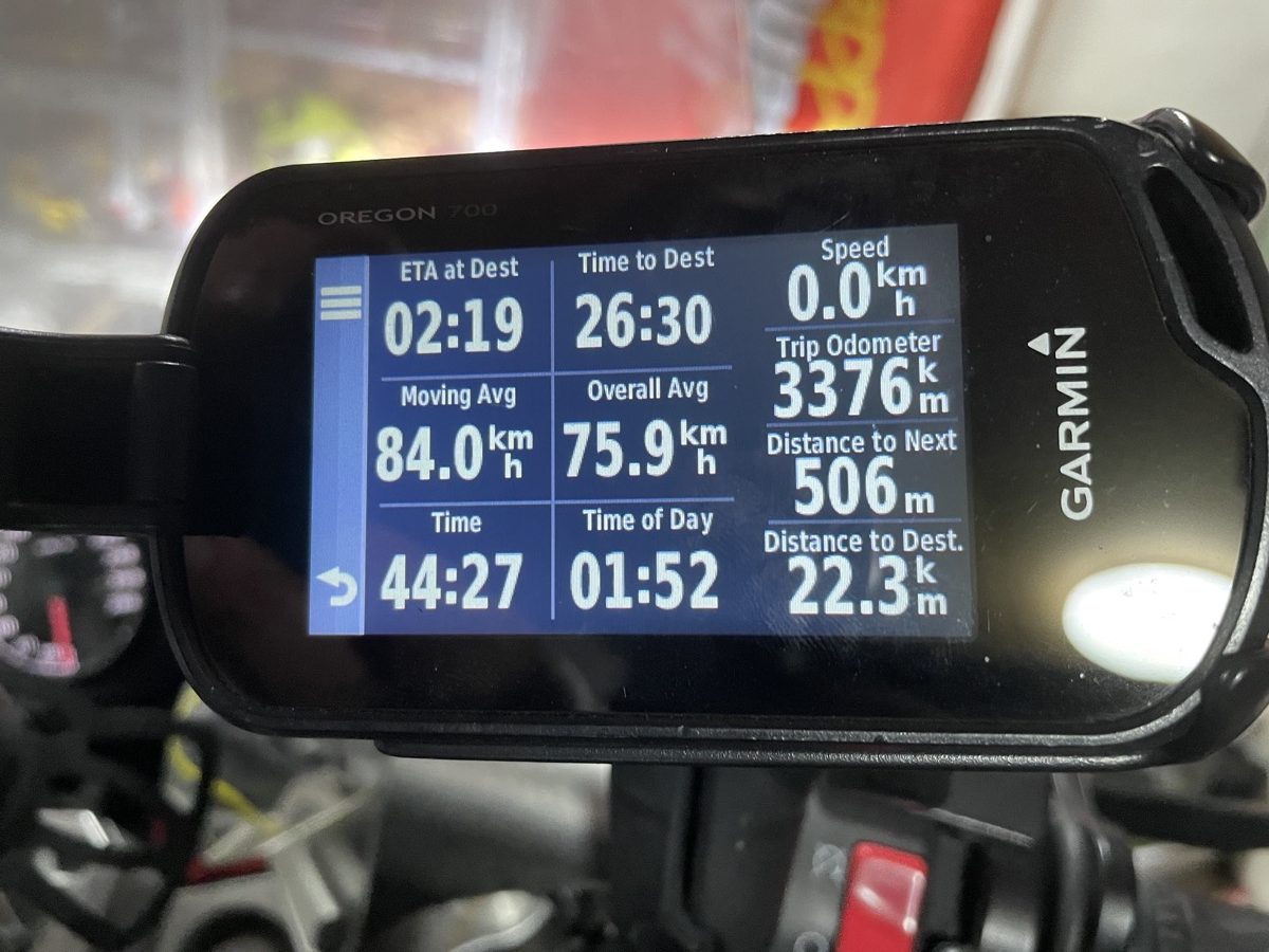
My morning timing was simple, out of the house by 3:30am, should get me to Warkworth by 3:50am – ready for a 4am departure. I took ODO photos at home before I left, I reset my GPS track and started my SpotWalla tracker from home @3:28am – My plan was to post all of these ODO photos all the way round, using SWConnect into SpotWalla, it’s convenient and once it’s done, it’s there for everyone to reference. I recommend this for others doing IBA rides. Julian did this too, which really helped to share his evidence with me and the IBA for all of his rides.
It was straight forward getting over to Warkworth from here, it’s about 23km from home to the petrol station including this in my route, out and back (if there was sufficient time to include it within the time window) would add 46km to my overall distance. It’s distance I was riding anyway, so if I could, then why not?… The official start and end fuel receipts were obtained from the same petrol station in Warkworth, so the timing on those receipts align nicely and also help to corroborate my SpotWalla captured track.
As I headed North out of Warkworth, I gave my Dad a call on Facetime, he lives in the UK, so 4am is currently 3pm for him, he’d taken an interest in the ride and planning and I think he was quietly concerned about what I had planned, so I wanted to say a quick ‘Hi’ to him and let him know that I was feeling good, well rested and that I was on my way. Before I had left home, I was joking with Stella that I’d need to remember to get off SH1 and head out to Marsden Point – I’ve ridden this Northern route a number of times and never had to head out that way, so there was a danger that if I was on ‘auto-pilot’ and not paying attention to the GPS, that I could sail past that checkpoint!… Thankfully I had remembered to follow the planning sheet on the tank bag when finding the first of my waypoints from Warkworth. 🙂
CP13 – Marsden Point
That road out to Marsden is not one I’ve ever done before, it’s nice, it’s a quick, open and flowing road and even in the light morning mist it was a pleasure to ride; I’ve never seen the refinery and the port at night before and the number of lights on their multi-story structures is pretty impressive, it looks incredibly futuristic at night as you approach out of the surrounding darkness. This photo was taken at 4:53am, so I was spot on time with the plan.

As Julian and I were riding these rides, one of our missions was to try to determine where would make good places for us to park the bikes up and to obtain decent checkpoint photos. These would feature in the ride documentation as guides for other riders. Finding easy to spot landmarks would help others and would help to keep the documentation requirements as simple as possible. There’s a few which Julian juggled with up to 2 or 3 times and he’s actually back out to one or two of them again today to get better photos for the guides. 🙂
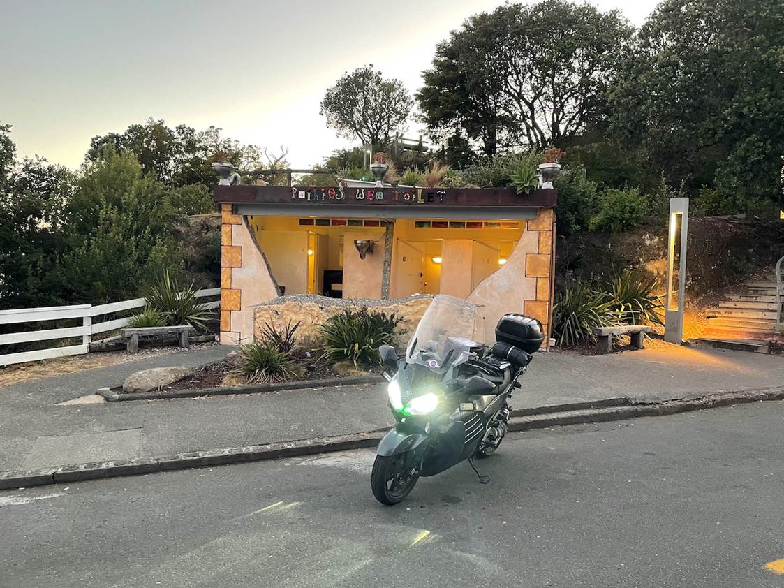
CP14 – Wee Toilet – Paihia
Anyway, back to the ride, heading North from there, up through Whangarei and on to the Bay of Islands, patchy morning mist in parts brought the temperatures down, especially heading into Kawakawa. I’d managed to find a nice and settled pace at this point and was starting to crunch away the kms. Daylight had broken by the time I arrived in Paihia and since the checkpoint was a toilet, I decided to use the facilities. The checkpoint photo was taken at 6:04am so I was just starting to hit the departure time of the checkpoint while I was still messing around with photos… I think I might have taken my pee after the photo was taken too, so I was already starting to drop behind the plan.
The next section out from the Bay of Islands, up to Keri Keri has been plastered with 80km/h zones, not something which my BaseCamp was aware of yet; so this leg was slower than expected. Before my next checkpoint I took a tiny detour South when I hit SH1 in Awanui, I filled up and uploaded my photo at 7:22am, against a plan of a 7:23am departure, so I’d managed to make up some of that lost time once I’d left the 80km/h zones… So far so good…
CP1 – Cape Reinga
My fuel stops were planned for 280-300km – With the bike re-fuelled, I could make it up to Cape Reinga and back down as far as Kaikohe, that was a 301km leg, this is the first benefit of riding these types of rides solo, you’re able to plan your stops precisely to your own maximum range and not have to short-stop because of someone else’s smaller tank. 🙂 The road up to the Cape is spectacular nowadays, it’s nicely sealed, the cambers are mostly amazing and at this time in the morning, most tourists haven’t yet finished their breakfast, so they’re not yet on the road.
As I got up there, the warden was opening up the top car-park, which was hilarious as it is supposed to open at 6am. I’d arrived just on 8am. As I rode passed her while she was making efforts to get the key into the padlock, I asked if it was ok to head on up, so I could use the toilets, she said Yep, laughing as she said she was a little late opening… 🙂

I used this chance to grab the first of my pre-made sandwiches, drink a heap of fluid, put some sunscreen on and make a little facebook video.
Check out the sky! – The weather was awesome, it was shaping up to become a pretty hot day. This photo was uploaded at 8:28am, my plan had me leaving here at 8:29am. – So the leg speed had been over-estimated and I was starting to get pretty close to the margins again…
I rode back down to Kaitaia and as soon as I hit the road out of the Cape, noticed how much more traffic was on the road, all heading North. – I thought to myself how much easier I’d made it on myself not to have to work through that traffic northbound and how lucky I was going to be southbound now, since there was no other traffic returning down yet. I was lucky all the way down, until just north of Awanui where there are some hefty sections of double yellow lines and a small number of cars were doing 20km/h less than the posted speed limit. I thought to myself, it’s going to be a long couple of days, settle and remember the end-game. I got passed them as soon as the annoying road-art had finished. Soon to hit the 50km/h zone on around the outskirts of Awanui. Again, I thought to myself, just settle… It’s a long ride. Sure enough, there were two patrolling police units in that 50 zone. I was very happy not to be their morning’s prize.
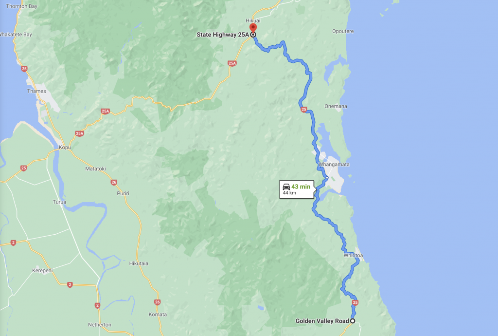
South of Kaitaia is the Mangamuka Gorge (not its formal name, it’s part of the Maungataniwha Range), this section of road has been closed since June / July 2020 and only reopened temporarily during the Christmas break period for 2-3 weeks, to help with holiday traffic. It has since re-closed. It was only temporarily opened to light vehicles while they perform some major retaining work on the side of the slumped road. It’s only in two spots, but it’s significant enough to have caused some major disruption in that area for 6 months! I don’t know how much longer they’ve got to go before it’s finished and properly re-opened. This also formed part of my plan in terms of when I wanted to attempt this ride. There are other routing options around this section of road, so it won’t make this ride impossible for others and that was a small factor in why we ended up allowing 50 hours for this ride, when we were putting our ride-rules together.
I’ve put together a video of this section when I was riding through on an earlier ride. – This is not from this ride.
That video was from our 2-Up SantaSore on 25th Dec, 2019. 🙂 – Just for fun…
Anyway, this time was much the same, although I didn’t have my mad-pillion on the back. 🙂 South of this lovely section of road, we head Westbound for Kaikohe and our fuel stop. The photo from that stop was taken at 10:48am against a planned stop, departing at 10:42am.
These times aren’t much of a drift, but when you’re riding against a plan like this, you become acutely aware of the pace and the trend which is setting in, clearly by now I was fully aware that I hadn’t adjusted my leg speeds and I understood why time was slipping away, because of this I was OK with it. I knew that I had many hours of slack time at the end of my plan, so following it to the minute, or even to the hour or two was not critical…
I took some more food onboard, I have a trail mix of nuts cranberries and chocolate pieces which I can ram into my mouth and chew. Tip: finish chewing this stuff before putting your helmet back on. It had started to really heat up. Heading between Kaikohe and Opononi, about 15km out from Opononi there are some nice straights between undulating corners. I was making good progress along here, the roads were nice and quiet. As I rounded a corner, at the end of that next straight, heading in my direction I spotted a police two cars, the last of which was a patrolling police car. Sure enough as soon as we could see each other, my radar detector fired off… He selectively continued to monitor my speed along straights and gun other motorists all the way into Opononi. This was fine, he was doing his job and I wasn’t speeding so there was no event to talk off. – But, he/she was being held up by the car in-front of him and seemed quite happy to use them as cover from oncoming traffic. I on the other hand, ended up gradually approaching the back of the police car and was soon being held up by them both. Yes, there was a legal margin left within the speed limit, no I didn’t want to sit behind them for an extended period of time, but really…. We’re getting to the point where we cannot have any confidence or faith in the NZ police to reasonably police any more. I have been pulled over by a unit on SH16 once, for simply overtaking them. – It was legal, I was under the speed limit, they pulled me over and told me that I couldn’t do that. – I was like, ‘what? overtake you? Yes I can…’, they said I wasn’t driving to the conditions and that there was a downed power pole around the next corner. – To which I laughed and said, ‘so you’re judging me and my driving based on information which you have and which I couldn’t possibly be expected to know? – Do you think I really wouldn’t have stopped in time for the hazard around the next corner?’… Anyway, that guy ‘let me off with a warning’ and told me not to overtake him again on the rest of my journey home! – This is why I have no remaining faith left in them… Anyway, with this particular one, they were already showing that they were unreasonable and thoughtless, by not pulling over to let me through, clearly their job was more important than the reasonable use and flow on the highway at that particular point in time, so I decided that under no circumstances did I want to find out, for sure, how unreasonable they wanted to be. – So I caved in, gave up to it, pulled back 150-200m and followed them at 80km/h for the remaining 10km into Opnonoi. They pulled into the RSA carpark, right next door to my next checkpoint, the Opononi hotel.
CP2 – Opononi
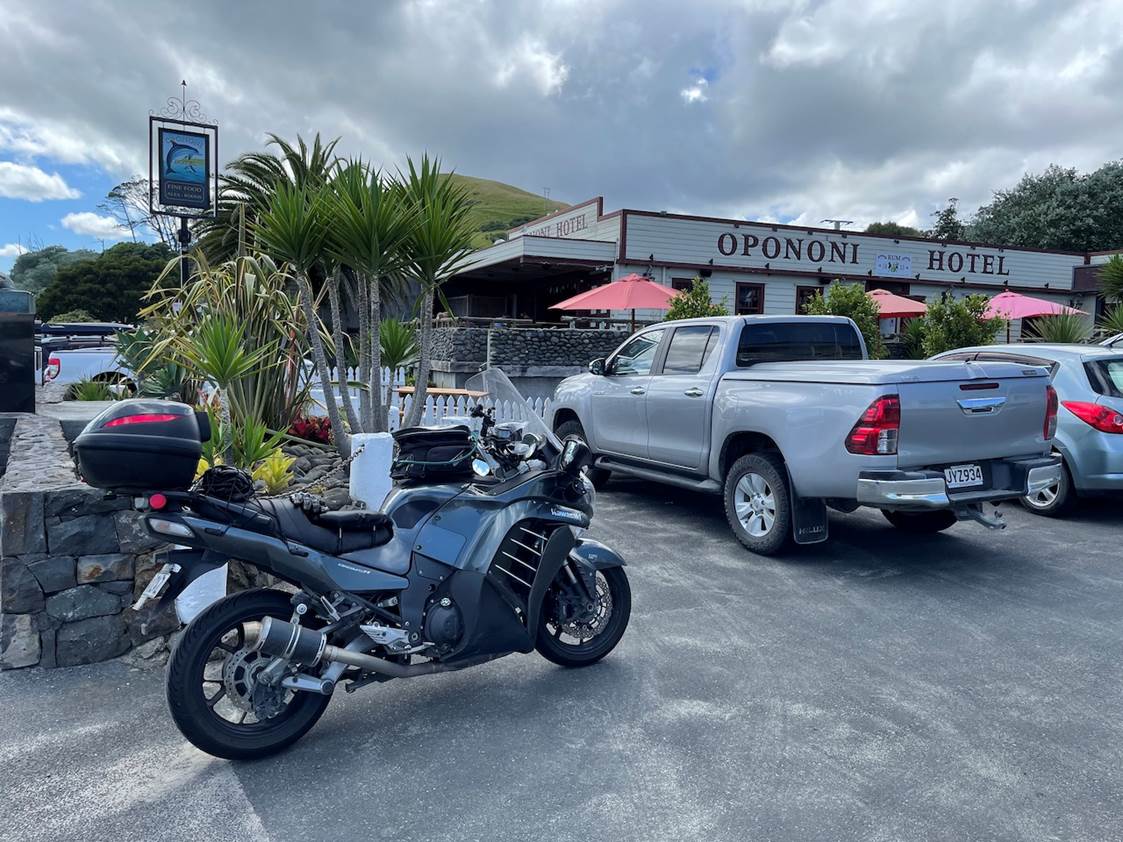
This was at 11:29am against a planned departure time of 11:17am. Time’s slipping away and there’s nothing I can, or should be doing about it. It is what it is, it’s a combination of planned leg speeds which were too fast from basecamp, my lack of adjustment and factors on the day. 🙂 I’m loving it, the weather is great, the bike’s going well. I’m comfortable still. It’s 25 degrees.
I shot some videos from this point in the car-park out, into and through the forest, there’s a 30 min youtube playlist here: https://www.youtube.com/watch?v=v898DkFUK4M&list=PL4OP4xZZoK32c68bFIiIMY_bt86b_K2CS
You get to hear me rant a little bit about the police car in this video too. 🙂 – And you get a little insight into all of the electronics crap I have on my bike. 🙂 If you want to skip ahead and just watch the Forest section, then you can use this link instead (it’s to a point, later on in the same playlist…): https://www.youtube.com/watch?v=OLHPTRaGris&list=PL4OP4xZZoK32c68bFIiIMY_bt86b_K2CS&index=3&t=70s
Here’s the first of three of those three forest videos from the playlist (embedded):
You can see from the time I’m happy to take in playing around with the GoPro, etc that I’m not particularly stressed about timing or pace etc.. 🙂 Anyway, the videos speak as much for the ride and where my head etc is at this point, it’s probably more of an accurate reflection that I can write…
I did enjoy the ride down through the forest, into and through Dargaville, back to the Brynderwyns and back onto SH1. There’s a second playlist which I made of various later parts of the ride on this first day: https://www.youtube.com/watch?v=o7OBOopRnn8&list=PL4OP4xZZoK32wQG8tzQbHtKQinQXmaH2N
I’ll also post the individual video clips in here as we work through them… This was into and through Dargaville.
This was on to Brynderwyn:
As I was heading South, I called my friends Luke and Nigel to find out what they were up to and to see if they wanted to head out for some of the ride, through Auckland and South to Raglan, they were keen. So we made arrangements for them to meet up with me at the end of my road, on SH16, North of Kaukapakapa. Separately I’d also been in touch with Stella and she’d figured out that I was likely to be very hot in my waterproof fabric riding trousers. So she’d thoughtfully offered to get home, grab them and head back out to that same spot to meet me as I rode through. The plan was to roll my waterproof ones up and cargo-net them to my back-seat and for me to ride in my summer mesh riding trousers instead. – Oh, my, what a relief they were! It was easily pushing 27-28 degrees at that point. – Thank you Stella!
Nigel and Luke met up with me, I changed my trousers, we got on the road as quickly as possible and carried on, no time for extended stoppages here! 🙂
Since this was an unplanned stop, adding time on the leg to Helensville, I filled up at 2:38pm, the plan had us leaving at 2:04pm. – So things really were slipping at this point…
It was perhaps about now that I started to do some maths in my head about timing, expected ETA in Whanganui, realising that my planned ETA of around 11pm was going to be well out, I had to reset my expectations and continue to focus on what was in front of me and not let any of this get to me, or make me change my pace or approach. It was a long haul and needed to flow, I didn’t want to start pushing, or forcing it.
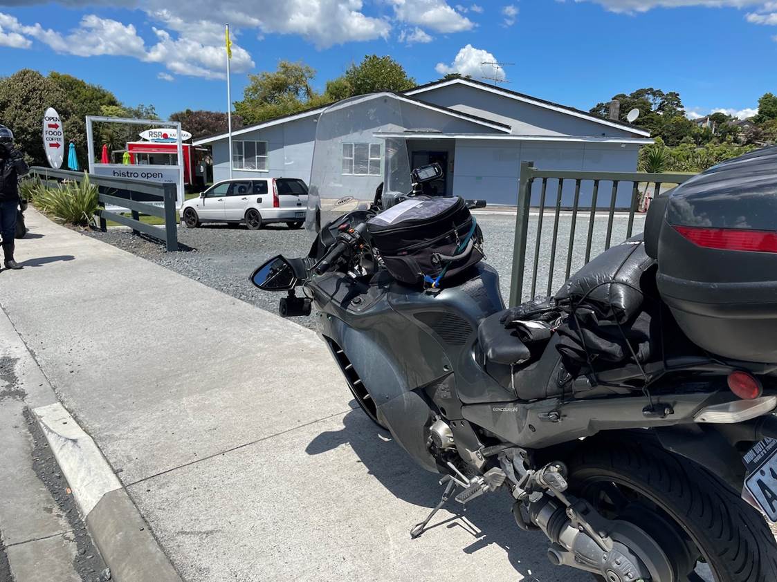
CP3 – Kumeu RSA
Next checkpoint was one on the route, simply to force a westerly route around SH16 in the North of Auckland area, the RSA in Kumeu.
We followed the planned, westerly route along SH16, down through the tunnel, towards the airport and re-joined SH1 at Manukau. Luke and Nigel helped to find some space through the traffic in Auckland, which was heavy, but flowing nicely. We didn’t come across stopped traffic anywhere along the motorway.
South of Auckland and I was being particular about the route we wanted to take, to closely mimic a ‘Ride Around’ route design from the USA. This meant we left SH1 at Drury and headed through Pukekohe and Tuakau. It’s designated SH22 through there, but it’s not, it’s an urban route at best, it’s residential, heavy urban traffic, with lights, round abounds, residential areas, commercial areas… It’s heavy and it’s rubbish. I’ve since posted recommendations on the official route to avoid all of this area.
CP4 – Raglan
South of Tuakau it opens up onto SH22 proper. This is a nice, flowing, twisty and very tight in places, State Highway, it’s fun in the day when you can see the dangerous subsidence in sections of this road. We all know about these now, so we know to take it extra carefully if you’re doing this one in the dark!… It’s not a particularly quick piece of road given the nature of it, but it is fun. This pops out on the Raglan highway and soon enough I was waving goodbye to Luke and Nigel who stopped to refuel, while I headed out to find a checkpoint. On my way into Raglan I saw another Connie rider, who it turns out was Rhys Wilson, he waved. Unfortunately we didn’t have a chance to catch up, but we did both spot and see each other.
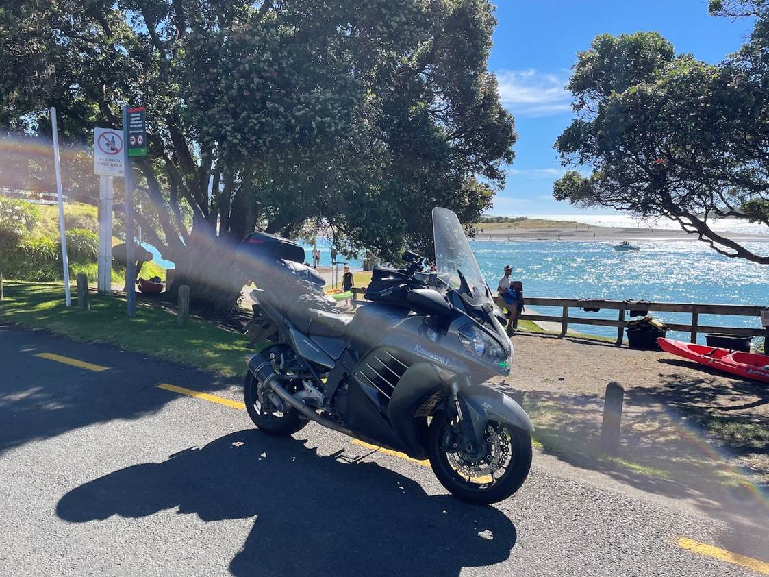
Raglan is such a pretty spot and a nice town for a get-away. I can recommend staying in the pub there and if you’re on a bike, they’ll often let you push it into their rear-beer garden which gets locked up at night and is under CCTV coverage too. – Anyway, here I scoffed another sandwich and also made another brief Facebook video.
Alone again, I headed back in-land toward Whatawhata, to join SH39, to my next fuel stop in Pirongia. The time comparisons against the plan start to become a little irrelevant now. But the rate of slippage does, at this point I’m about 25-30 minutes behind my plan and I’m at 1137km, so it might be reasonable to think that across the first 1600km, I might arrive about an hour or so behind where I thought I might. The two key milestones to aim for then become Whanganui by around mid-night, or Foxton perhaps by about 1:30am (if I don’t stop in Whanganui).
The next part of the journey was one which I was looking forward to, since it’s another one of those bits which I’ve never done before, not even in a car, the SH31 trip out to Kawhia was amazing. The road is like a goat track, narrow and twisty, but the views are amazing. I loved this bit.
I was having a little difficulty in getting the GoPro to turn on and start recording, which is why I’d pulled over to try to get it to record. – Sometimes tech gets too much to be bothered with when it’s not straight forward and when it doesn’t run perfectly. But I was enjoying this section of the ride so much that I felt it was worth taking a little time to stop and to try to capture it for you guys. 🙂 I know this content isn’t edited, I know it’s full of wind-noise, bike noise and other rubbish, it’s only really to give you a feel for the day, the roads, the ride etc… I’m not hoping to win any awards for video production. 🙂
CP5 – Kawhia
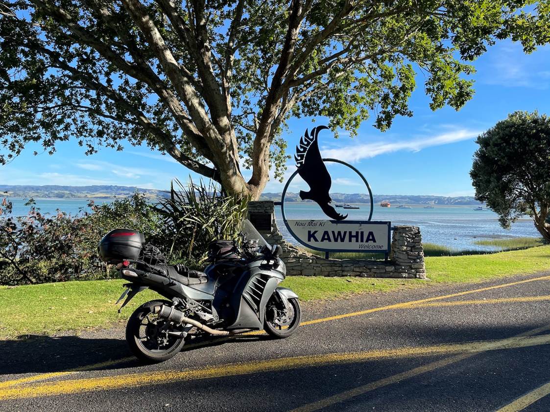
This beautiful landmark was about 400m short of where I had intended to stop, but it was so perfect for a checkpoint I couldn’t resist it. You can see how quickly and directly we found it if you watch the above video. I didn’t even know this was there! 🙂 Quite a find!
There are three videos in the playlist heading back from Kawhia to SH39. Rather than link all three in here, here’s a link to that point in the playlist: https://www.youtube.com/watch?v=pQwcqc0iKrg&list=PL4OP4xZZoK32wQG8tzQbHtKQinQXmaH2N&index=4
CP6 – Waitomo
On the way back out to Kawhia, I had convinced myself that it was the last ‘out and back’ for a while and had completely forgotten about the next one, which was at Waitomo… Arrhhhh. Ok, this were all little facets of the ‘Ride Around’ route design and to be honest at this point the Waitomo one was a little bit of an annoyance… Still, I had to do it, it was all part of the plan, part of the expected route.
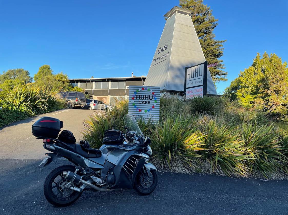
This stop was at the Huhu cafe, in Waitomo, the closest landmark to the end of the SH. I was quite happy to grab this one and then start the major part of the trip into and through the Awakino Gorge. I was really hoping that I would get through most of that before the sun-set. I was feeling really good still. Not tired, not distracted, I was still very happily focussed on the task at hand and getting on with it, I felt like I was making good progress. I’d spoken to Stella a few times on the way down to Kawhia and back we were saying how we must make some time at some point and head out there again for a weekend away. I was also talking with Luke about timing on the way down to Raglan. He used to travel the New Plymouth route regularly and knows the Awakino route very well. He reckoned that I would just make it through to the other side of the gorge in daylight. – Turns out he was bang on with those comments.
I had originally planned a fuel stop at Urenui, with a 281km range. I knew that the station closed at 7:30pm and as I was running, I would miss that station. Stella and I had already talked about that before I had left home and I had already figured that I would easily enough make it through to New Plymouth to one of the 24-hour Z stations there, if needed. Well, that fall back plan just became my plan A. I like the road through this way, it’s nice and simple highway, you can hold a very steady and good pace, there’s plenty of space for safe passing etc, so slower moving traffic doesn’t have to hold you up for long. There are a couple of traffic-controlled sections, neither of which held me up for particularly long. I popped out of the other side of the gorge just as the sun was setting and grabbed the following:
Just a little later on, I figured my Dad would be waking up in the UK, so I stopped again to take a photo and to show him the gorgeous sunset on FaceTime. – Also to tell him I was OK and that things were going well:
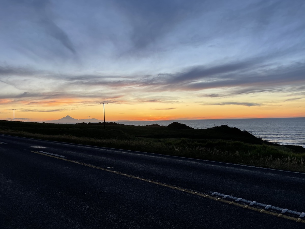
Open up the full-sized version of that photo and check out the cloud off the top of the mountain, it’s beautiful… Not much further on, but in the proper darkness I arrived in New Plymouth at the Z station to fill up, eat a pie and have a drink. I should tell you that all the way through the ride, I’ve had easy access to electrolyte drink in my camel back, which is in the top of my tank bag, with the hose lodged in one of the tank bag straps, easy enough for me to reach and insert into my helmet as I’m riding. So I’ve been slurping and sipping fluids all the way round during the day. The station attendant was good enough to agree to keep an eye on my bike while I went for a pee stop there. 🙂 – Thanks Z guy!
CP7 – Opunake
The next section of highway is one which I’ve done at all different times of the day and I know it pretty well. There’s little there to catch you out and it’s also not overly busy most of the time. I arrived in Opunake for a checkpoint photo by the library there and there was absolutely no-one around at 11:08pm. I was supposed to have left here at 9:48pm, so I was tracking about 1:20hr behind my plan. It was very clear to me that my hopes of a potential SS2000K were done. While I’d been keeping a good and steady pace, it certainly wasn’t one of the quicker rides which we’ve managed to do. And, again my eyes were on the bigger prize, that of being able to do this for 2 days, not just the one. – So I was OK with that. 🙂
On the way into Taranaki I had been talking with Stella about my various options, whether I would plan to stop for sleep, or carry on. I had decided to call Al on the way into New Plymouth to double check that our plans were still OK and to let him know that I would be stopping in. I wasn’t feeling specifically tired yet, but felt that if I did stop, have a shower, clean my teeth have a little snooze etc, then I might feel empowered to push on. – So I headed to Whanganui.
I arrived there at almost exactly 12:30am. I set myself a goal of being back on the road in 2 hours. My head hit the pillow at 1am, alarm set for 2am, I planned to eat after I awoke so that my body wasn’t telling me, hey – you’ve had food – let’s go! I wanted to sleep, so I settled down as best as I could and I grabbed a solid hour. I felt good when I woke up, ate a pie which they’d made for me, had some water to drink and was on the bike leaving at 2:23am.
I still didn’t know if that was a good idea, whether it would be enough sleep for now, or anything, we were in uncharted territory (for me) at this point. But, I rode out, into the darkness again, feeling as good as I had in the earlier parts of the evening. Next stop was a fuel stop in Foxton, then on to Wellington. – I crossed paths with Phil Biggs as I came into Foxton, he saw my green city lights and recognised the bike. 🙂 Phil was heading out to complete an otherwise unfinished, previous NI1600K ride, which he managed to complete successfully – Congrats Phil!
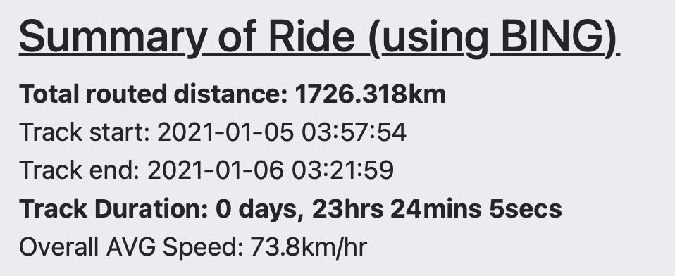
The fuel station in Foxton was a significant stop, as it was my last receipted fuel stop, before the 24-hour period from leaving Warkworth expired. This became my finishing point for my SS1600K certificate. Doing SS certs in this way, heading out and continuing to ride until your time is up, is an interesting way to maximise the certified distance on your certificates. 🙂 – I managed 1726km on this and chose to make this a “MS1000” certificate, one in support of MS Research in the USA and supporting Paul Pelland’s ‘1 million miles for MS’ campaign.
CP8 – Wellington
Pushing on to Wellington, I rode through the capital at 4:45am. It was deserted, with almost no cars to be seen. I navigated through the city highways, through the tunnel and out towards the airport, to go and collect the Windy Wellington sign checkpoint photo.
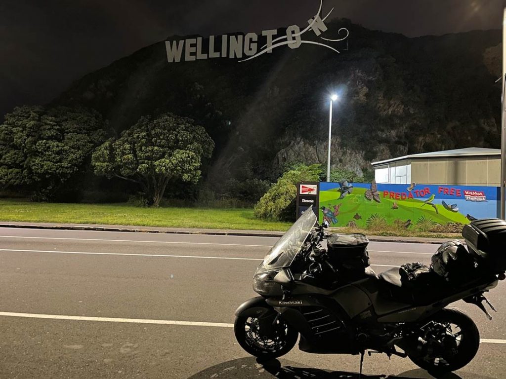
I really like this photo, it’s one of my favourites from the trip. 🙂 Anyway, just after I’d pulled up there, before I’d even taken the photo I think, a white ute came quickly passed me and swerved into the parking bay just in front of me. Jeez, I thought; then this big guy gets out of his ute and starts walking directly back to me, with a purpose…. ‘Ooops, I hope I didn’t cut someone off’, I thought and he was a big fella… I’m thinking, I’m alone here, it’s before 5am, am I in trouble? Then I notice it’s Stretch. ‘G’day mate! – How ya doin’?’ – Well was that a relief?
‘I’ve been following you down from Whanganui’, he said! – I’m thinking, wow, that’s a long way… – Nah, on the tracker!… Ah, ok. But, that was hours ago, I left there at 2:30am! WTF? – ‘What are you doing up?’, I asked him. – ‘I’m out to see you!…’, he responded. ‘Nah, I mean, what are you doing up?’, I asked again… ‘I’m here to see you!’…. Oh, ok, it sunk in… There are nutters at home as crazy as the other nutters who are out riding… 🙂
Thanks heaps Stretch for popping out, staying up and looking out for me in the middle of the night. Your unexpected, ridiculous pre-5am visit to my checkpoint was amazing, I was truly grateful and it picked me up no end. – I didn’t need picking up, I was OK and going well, but it was a massive boost none-the-less. Cheers. I didn’t get a selfie with both of us, we stopped and chatted for a while, I was relaxed, feeling good and didn’t feel rushed to get on and ride. I was quite happy for the company and a chat. 🙂
Clearly at this point, being 1.5 hours behind getting into Whanganui and having stopped for 2 hours, I knew I would be approximately 3.5 hours behind the plan at this point. – I’m telling myself that’s OK – since I knew it would be way out by now… But I start to examine the end of the plan, to recap on how much time I have at the END of my ride, how much slack time I can eat into, before I start getting close on the other end.
My plan had us unrealistically arriving back into Warkworth at 6:42pm, add on the 3.5 hours which I know I’m behind that now, along with some knowledge that the rest of the plan would have been optimistically paced and I’m looking at an arrival time after 10:30pm. Ok, well all I could say at this point was that, I had approximately (between 10:30 and 4am) in the way of spare time left. – That was 5.5 hours. – This is the value of having some level of detail down, even if it’s not 100% accurate, it’s something from which you can plan on the fly and make some decisions off.
Ok, 5.5 hours spare and how far to go? – My Wellington checkpoint was at 1,841km into the 3,346km plan. So, good news, I’m more than half way and I have only 1,505km left to go and I have 5.5 hours spare. – So I started to relate that back to a normal SaddleSore pace and I thought if I had 5.5 hours spare on a SaddleSore, that would mean an 18.5-hour pace. But I’ve got 100km less than that to do and I’ve still got those 5.5 hours too… Which in a round-about way was a recognition that I had plenty of time; I didn’t need to keep that 5.5-hour margin through to the end, I was more than happy to use as much of that as I needed to.
I also reminded myself at this point that while I had set a 48-hour goal, I was doing the proofing ride, which in essence means that whatever it reasonably takes me to do the ride, is the timeframe which the IBA would consider to be a ‘fair and reasonable time’ for the ride to be done it. – Assuming that I didn’t go way too fast, or have any issues which meant I needed to take extended and unexpected stops. – While I was aiming for 48 hours, it would be ok if it had taken me 50, or maybe even up to 52 hours to complete this. Especially since we were basing this off a SS3000K, but the distance I was aiming for was another 10% beyond that. Reasonably then, it could have, perhaps taken me 10% longer than the 48-hour allowance for a SS3000K. Knowing this was useful, but I didn’t want to test that, if I didn’t need to.
So we pressed on. Steady as we go… Leaving Wellington, as the dawn was breaking, I could see some really heavy clouds over the Pakuratahi Forest, I hadn’t appreciated how far North the Remutaka Hill pass was and for a while there, I’d thought I was going to have to ride into that horrid, dark and wet weather. I was lucky as we went through the Upper Hutt portion of SH2, it had been closed overnight and I was expecting to have to take a diversion into the Upper Hutt streets to get around the closure. It was due to open at 5:30am and I was passing through there at 5:28am, they had reopened it, so my passage was reasonably easy.
I called my Dad again because I was still on a little bit of a high about Stretch making the effort to come out and I wanted someone to share my enthusiasm with, he was the only person I could think of who was going to be awake at that point. 🙂 – We had a nice chat as I headed up into the base of the Remutaka Hills. That’s a lovely piece of road and how wonderful to be able to do it at that time in the morning when there’s virtually no-one else using it at all! I’m not much of a morning person, so you’d rarely find me up and doing these types of things at that time of day, for the hell of it. But I am always pleasantly surprised about how many of the nicer riding moments seem to come from when the sun comes up. Each of my LD rides where I’ve been riding when the sun has risen has added a really special, memorable moment. For me, this time also signifies the start of the day, the point at which tiredness starts to fade, as the body kicks off the feeling that it should be asleep. Daylight definitely helps you to feel awake. So does Coffee… 🙂 – And I do tend to like my coffee in the morning.
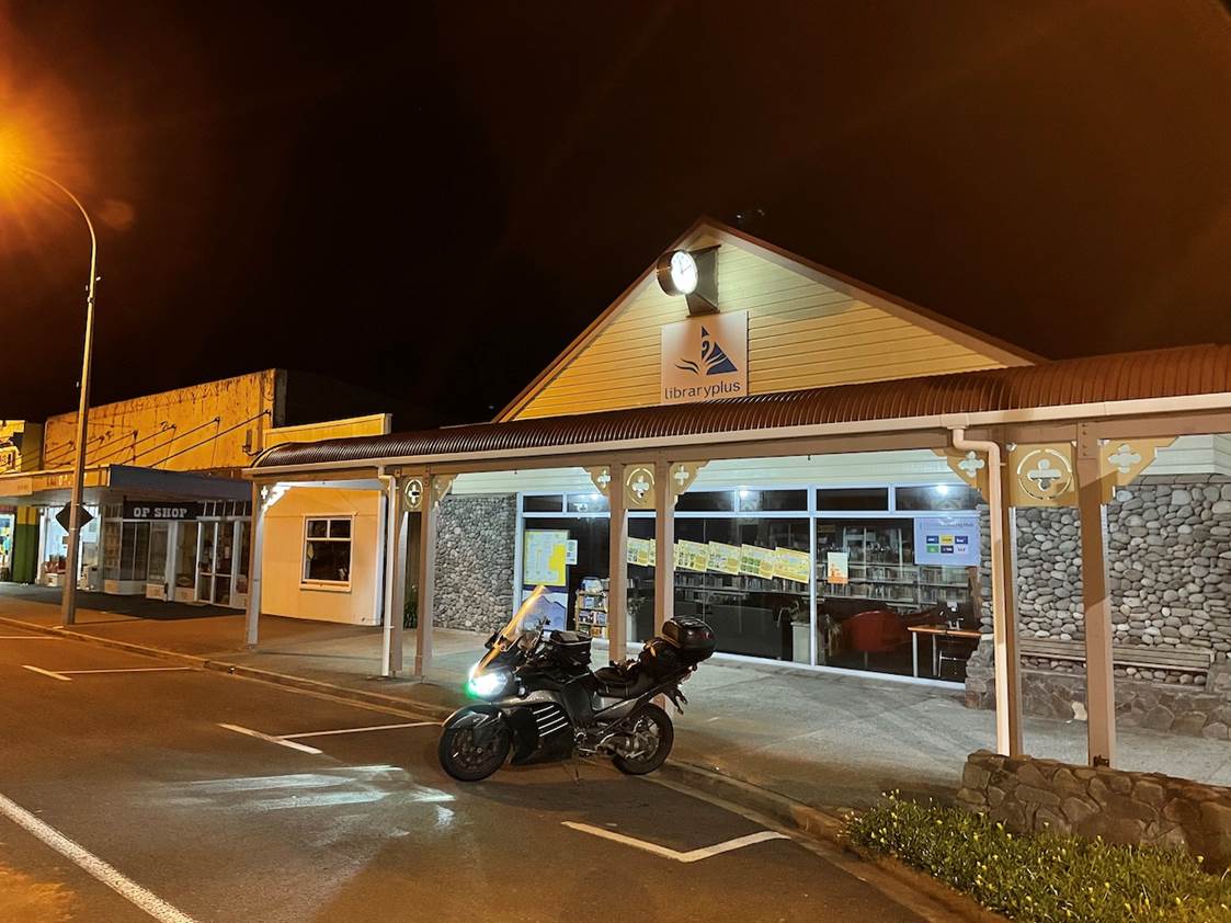
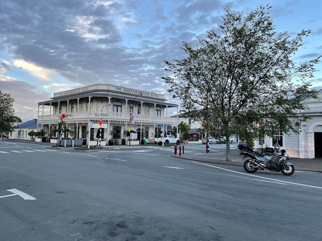
CP9 – Martinborough
As I headed through Featherston, I’m back onto roads which I know pretty well since I’ve spent a bit of time down this way touring with Stella. I start to think about the next checkpoint, one which I was delighted to need to include in the ride’s route planning – Martinborough. We love this little town, it’s beautiful. In my head I know the checkpoint photo which I want to take, one of the Martinborough hotel on the main town square, one which shows the whole of the hotel with my bike in the foreground. We’ve spent a bit of time here over the years, with various trips for wine-tasting and also for ‘Taste Martinborough’, we have our favourite cafe on the square, nearby to the Martinborough hotel. I start thinking about treating myself to a nice cafe breakfast, if they’re open!…
I arrive and sort out the photo, it’s another stunning photo, quite a moody sky, it’s perfect, pretty much exactly what I was hoping for… And it was 6:15am… Perhaps the cafe will be opening soon?
So I headed over there, re-park the bike directly outside and could see that the door is open and one of their staff was starting to setup tables outside. 🙂 – I might be lucky!… So I headed inside and said, ‘Hi, I’m in desperate need of a coffee, can you help me please?’. – ‘Sure!’, was the reply. 🙂 – Yes!… So I grabbed a bagel and a coffee and sat down for a short rest stop.
The video was shot when I was waiting for the bagel. 🙂 It was delicious (sorry, no photo). The next part of the ride was where I would have had to have gotten to, within 24-hours, in order for me to have achieved my SS2000K. So you can see, dropping that idea earlier was definitely the right thing to do. At this point I was still 80km short of that 2000km point and this was at 6:30am, 2.5-hours behind where I would have needed to have been for that SS2000K target, taking off the 2hrs stoppage in Whanganui, I would have been 30 mins late, with 80km still to go… Good call!
North of Martinborough, there was a route choice to make; should I head back into Featherston, staying on the SH’s or should I cut across and get back up to SH2 more directly on some perfectly reasonable back-roads? It was a no-brainer to me, tracking back to Featherston was not going to add anything to the ride, apart from distance and I had *plenty* of kms, so I chose to cut back up to SH2. On those back-roads I had two little dogs run out from a house, onto the road and had to do emergency braking to avoid them. – I did miss them, then alerted other traffic heading down that road to watch for them. This was the only close encounter with wild-life on my entire trip.
The next section of the ride is pretty plain, it’s just up SH2, sticking to the highway, making sure your speed doesn’t creep up and without too much in the way of proper stimulus (curves etc) it became the hardest section of the entire ride for me. I resorted to playing music, calling people, moving my windscreen around a bit to change airflow, standing on the pegs etc until it got a little later in the day and I got a little further North. I passed through Eketehuna and didn’t see an of those gorgeous Tui women anywhere!…
CP10 – Napier
My next checkpoint had me heading into the South of Napier, through Clive. There is an SH based route which takes you in that way and again, trying to ensure the purest possible ‘Ride Around’ route, it took me into the city that way. Arggggh, horrible residential route, lots of traffic, slow, slow, slow… Avoid it, we’ve made allowances in the routes’ documentation for you to skip that bit, again it really doesn’t add anything to the ride, apart from pain… When I got up to the checkpoint, it was pretty difficult finding a reasonable place to stop for the photo. It’s so close to the entrance to the main port that there are constant truck movements and at that time of day, lots of people using the cycle paths, so I had to ride around a bit to find a reasonable location.
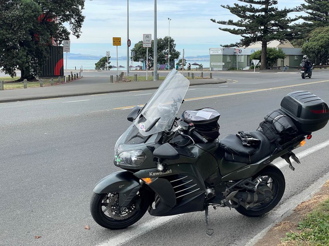
I was hoping for an alternative angle, showing the containers in the background from the RHS view in this photo. This however, shows both the containers and the Seafarers Centre in the background. It will do, it wasn’t worth spending any more precious time on this. I headed up to the Bay View BP to refuel after this. I was hoping to get a Mocha there and a bit to eat, but it was SO busy with holiday makers, that I canned that idea and carried on. Bay View represented about 1,110km left to go and all on roads which I know pretty well.
It was at this point that I pretty much figured that I could do this… ‘It’s only a 1KC from here’ – roughly. 🙂 I figured knowing the distance, the roads etc, I would have about 13.5 hours of riding left to do from here. It was 10:20am, so I knew it was looking pretty comfortable for a 1am finish in Warkworth, or thereabouts. Knowing this too meant that I figured I had about 3 hours spare still. Which was helpful because I figured if I needed to have a stop for a snooze, then I knew I had up to 3 hours to use if needed.
Knowing where you are all the way around the route (against a plan or a yard-stick) is critical; if you know that, you can make plans on the fly, adjust your plan accordingly and know within what parameters you need to continue to operate in order to be able to achieve the end-goal. Conversely, not knowing this will add stress and pressure and create situations where you feel you cannot necessarily take that extra time you might need, in order to be able to do this type of thing as safely as possible, or to know when things need to be done differently, or even – when to pull the pin.
I rode up through Gisborne and on the way through there, I was talking to Stella again on the phone, I was also lucky enough to have had calls from Howard (IBA) almost every couple of hours, checking in with me, seeing how I was going, offering advice in terms of management of fatigue etc. Through these chats, I had decided if I could find somewhere just North of Gisborne to park the bike up, under a tree, then I would do that for 20-30 mins kip. Well, I looked and I looked some more. I was happy to keep looking as I rode on. I wasn’t desperate, but had I found somewhere really pleasant, by the sea, in the breeze, under a tree, I would have unpacked that picnic blanket from my back-seat, laid it out, used by waterproof trousers as a pillow and kipped. But I didn’t find anywhere which appealed and clearly, I didn’t need it that much as I was happy to keep on riding.
And keep on riding I did… Right at that point I seemed to pick myself up again. It’s almost like having the plan and being able to have the plan to stop, was almost as good as actually carrying it out. – It’s hard to explain that any better, perhaps it was the road change again, North of Gisborne and how it became more challenging again, with more twists? I really, thoroughly enjoyed the East Cape and I sailed though it with ease.
Callum Floyd popped out to see in Tologa Bay. He was stood waving pretty frantically on the side of the road, wearing his green NZDR NI1600 T-Shirt form last year. I recognised a mad waving man wearing that shirt from a wee way away, so I was happy to stop and have a chat with him. 🙂 I really appreciated the effort to do that, it was very kind of you Callum, thank you.
I’d stopped at Tokomaru Bay in the GAS station and lost 15 minutes trying to buy fuel. It’s a card only station and the card reader was failing to read my chipped Credit Card properly. It was returning ‘Transmission Error’ messages on the receipts, not ‘card reading’ errors and so I hadn’t thought that the issue was with the card which I’d offered it. The lady in the local Four Square there, said, do you have another card, a non-chip card perhaps? Ummm, no, they’re all chip cards! …. Then I remembered I had my BP fuel card which is a swipe card. – We tried that and it worked… That’s a useful lesson for us all perhaps? Oh and boy was it HOT at that point, I was a sweaty, horrible mess once I’d finished filling up there!
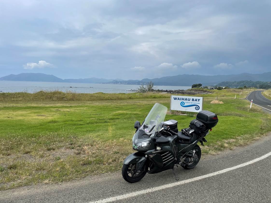
CP11 – Waihau Bay
Next checkpoint was on the Northern side of the East Cape at Waihou Bay.
You can see some of the overcast weather that had started to creep in once we hit that northern edge of the cape, none of those clouds were present until we popped over the top. 4:02pm and the plan was starting to become more useful in reverse now – looking at the remaining time to the end and applying it to the time which we’re at, adding a margin and then figuring out what remaining margin to our target 48 hr time was left. “10:49am until 6:52pm on the plan”, meant just over 8 hours to go, add ~30 mins for a margin; 8:30hrs remaining. It was 4:02pm. So 12:30am, so I’ve got 3:30hrs up my sleeve, 3 hours to be safe?… OK, still going well.
I was not looking forward to the upcoming section between Ohope and Whakatane, I know it’s busy, slow and full of holiday makers. I’d planned a stop in Whakatane as it was on an SH and I needed to go there. It was slow, it was busy, it was pretty painful getting through that bit. If I did it again, I’d ride around Ohope and bypass Whakatane. This isn’t a compulsory stop, so those who do this ride in future have the option to either do it ‘strictly’ according to the intent, or to relax a little and just grab the checkpoints. There’s no difference in the recognition or certification, it’s a bit like the Solstice and Equinox rides being given to those who ride for only 1 minute on the day, it’s valid and you will know how you did it. It’s a personal decision to make and you won’t be externally judged for it. (Much). 🙂 – I wouldn’t do it again that way, just sayin’.
I found the 110km/h section of SH2 and loved it, so smooth and fast and pleasant to ride and also surprisingly long! I was working my awkward way around the extemitous SH pathways of Tauranga in no time (again down to ‘purest’ routing choice)… I had to stop on the way heading out of Tauranga to put more sunscreen on, because I was about to head into the setting sun for sections of the next bit of the ride and my face was already looking somewhat pink.
The section of road between Tauranga and Waihi has been painfully reduced in speed limit with new blanket 50k speeds for quite some way. These are temporary I believe while they perform road works on those sections. North of Waihi you join SH25 which on some rides can be a LOT of fun and really pleasant to ride. After all of the twists of the East Cape and the length of the ride my body was starting to hate having to break for tight downhill corners. I found this part of the ride a real physical struggle and I was really very happy to have made it through to Whangamata. North of where SH25 is joined by SH25A, it settles down a lot and becomes much more agreeable, I was very happy to be off the very tight and twisty section which SH25 had thrown at me.
That Whakatane fuel stop was intended to see me good, up to the township of Coromandel, where I was planning on grabbing my last fuel of the day before the finishing point. However, Coromandel is known to shut at 7pm, with the neighbouring station shutting at 7:30pm. I knew I wouldn’t make that and again Stella and I had talked about that possibility before I had left home. I knew that there was some 24-hour option available in Whitianga and that short-filling there would still give me enough to get all the way up to Warkworth. It was one more stop regardless of where it was, so I deviated in Whitianga and found that 24-hour station.
CP12 – Kuaotunu Bay Lodge
At this point, it really felt like it was the home-bound stretch. I know the top of the Coromandel pretty well, I’ve done it a number of times on LD rides. It was properly dark by now, the roads were quiet again and I was enjoying being able to use my lights. Only one more checkpoint to grab before the final leg up to the finish point. The last checkpoint was up on the Northern edge of the Coromandel at Kuaotunu Bay Lodge:
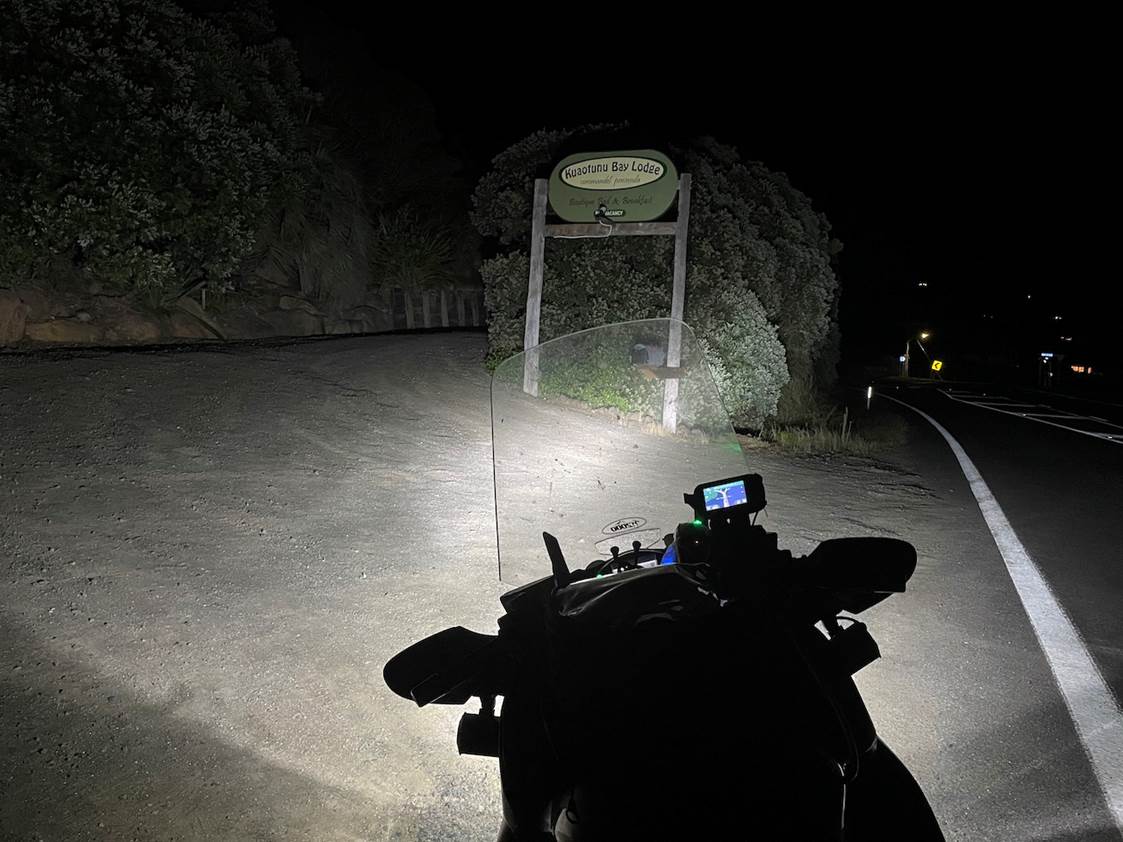
Perhaps when someone gets a better photo of this checkpoint we can replace this one in the ride documentation, anyway. One final check of the timing before I headed out. This was 10:12pm and it was thought to take just under 3 hours from here to finish. So, sometime around 1am, I should be back in Warkworth… This was great news. I had no plans to stop anywhere else now, until I was back at my final fuel stop. And that would still leave me around 3 spare hours. I felt I solidly had this in the bag now, barring anything going wrong. I was feeling really good, amazingly I was totally awake, that night time riding through the Coromandel had really fired me up. That, probably combined with the finishing line being almost in sight, I was feeling really good.
Heading over the Coromandel hill, I was stuck right behind a ute driver – who clearly thought he was driving that road well. He was not going to pull over for me, or help me to get passed him and while he was driving like that there was nowhere safe on that road for me to pass him. It took him right up until part way down the other side to realise he really was holding me up and he indicated left for me and let me through. Within 2-3 corners I couldn’t see his lights anymore, so I wondered if his wife was in the passenger seat and had started to bash him?
My ride from Coromandel Township down the Coromandel was one of the best rides I’ve ever had down that section of road. It had just gone 11pm, there was no traffic on the road what-so-ever and I was really able to find my own pace down there and get a good flow going, not overly fast, just a perfect flow. Even though it was dark, my lights were highlighting the beautiful Pohutukawa trees and even though they weren’t red in flower any more, their majesty along both sides of the road there was still something to behold.
I got down to Thames steadily and headed in-land along SH25 to SH2 and at Mangatawhiri I got quite a good surprise at the old ‘castle’ cafe building. Stella and Luke had ridden out to meet me. They were planning to hook up with me near the Bombay hills, but had ended up being significantly early, so then decided to venture out and down SH2. 🙂 – I knew they were coming, but didn’t expect to see them there. Apparently, they had been tracking me on Find My Friends for a more accurate location than the 5 minutely SpotWalla points was showing. They were started and ready to go as I rounded the corner. Amusingly, our Cardo Packtalk comms kits had seamlessly paired in DMC mode as I neared them and we just kicked off casually into a conversation without anyone having to do anything. 🙂 – ‘Oh, hello….’, ‘Don’t stop, carry on, we’ll join in…’, ‘OK… – hi!’… 🙂 And we rode on.
Nice to have such fantastic support from family. 🙂 – Luke and Tania had work the next day and peeled off, heading home when they hit their off-ramp on the North Shore, Stella and I rode on to Warkworth and grabbed my formal finishing fuel receipt. 🙂
My finish point – Warkworth

Time on the SpotWalla log for this point was 1:22am – just under 46 hours from when we left home. Because the whole thing was SpotWalla tracked and the receipts all the way around corroborate the track which had been captured, adding in the small amount of milage to and from home, into the ride’s time and distance, even though they fall outside of the official receipted times, is somewhat acceptable. Without all of the other documentation this might perhaps not be accepted, but the ride was verifiable from within the receipted timeframes and distances anyway, so pilling on that additional ~hour and 46km does nothing harmful. So, I rode home with Stella from that point and recorded my ride’s end-point at home.

Closing remarks
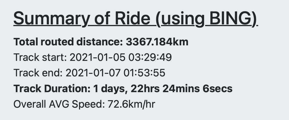
As far as the GPS details go, remember that I had just under 2 hours of downtime in Whanganui when I stopped for a rest break. During this time my GPS was powered off and was taken off the bike, which is why the overall time shows only 44.5 hours, whereas my true ride time from home to home was actually 46.5 hours. This ride is do-able in 45.5 hours and we’ve set the riding time limit at 50 hours. My distance was 3,376km, but 46 of them was from home and back, so the true route distance would have been 3,340km. We’ve since made some allowances in terms of strict routing requirements and if you were to cut some of those corners, you could get this done in closer to 3,300km, collecting all checkpoints. The minimum required distance for this ride has been set to 3,200km – with an acceptance that if some of the checkpoints are genuinely inaccessible due to road closures, document it and you can potentially get away with up to a single missing checkpoint as long as the minimum distance is still done in the timeframe and as long as you continue to get all other checkpoints.
This was an extreme ride. It was long. It’s the longest ride I’ve ever done.
This ride will not be for everyone. I don’t expect that everyone who tries to do this will be able to complete it on their first attempt. There are time and distance challenges in this ride, timing challenges too.
This ride is worthy of decent planning and a lot of respect when attempted, it needs a measured and cautious approach.
This is the 10th certified ride I have done in excess of 1,600km in 24-hours. – It’s important for me to convey that you shouldn’t expect to be able to do this safely, straight off the bat and without any accumulation of similar experience.
Having said all of that, this was a ball, I loved it, I had a great ride. It’s a good, solid amount of personal time; I’d recommend if you are going to try this, that you plan to do it solo – keep things simple and focussed on yourself and your own effort, doing so will allow you to be tuned into just your own requirements and your own body / mind’s state.
Attempting this without the due care and respect would be, clearly, reckless. Putting this out there, for others to aim for, to try and to complete (successfully) is our aim. Hopefully you’ll find this write up and the actions of both myself and Julian inspiring. – So, if you’re up for it, get out there and give it a go!
This ride is open to all who have already done a verified 1600K IBA ride. It is a requirement of the ride that you are already an IBA member, that’s the first written rule. The rest can be found on this page here: https://ironbutt.com/themerides/nz/ratp/
Hope to see you all out there and doing it, soon!
Thanks for the great write-up Chris. Well done for all the work you put into creating the rides and congrats on your proving ride!
Thanks bud! 🙂 – I look forward to seeing you guys down South, next month!
Well done Chris. That is a huge ride!
Just a question regarding Basecamp – I have only ever used it for mtb gpsing, so no average speed changes needed doing. I am wondering how you adjust the average speed of various legs.
Also, as an aside, I have used Spotwalla and have viewed your “how to” posts but I find Spotwalla very hard to undestand/erangle as a non computer savvy person. Do you need constant cell service to run the phone app?
Hi Dave, Thanks for the kind words. You can set your ‘activity based routing – speeds’ in basecamp, go into options, find your activity types, and in the PC version of Basecamp, you can then edit the speeds for different types of high-ways. – Over time, tweaking these to your own riding style will provide better, more accurate routing details out of Basecamp directly. – What I was talking about in my ride report isn’t really this though – I know that the outputs from Basecamp for my activity types can be a little high and what I tend do to is take those waypoint and leg details out of Basecamp, and put them into a summary sheet in Excel. – I have formulas there to calculate and show me the average moving speed for each leg, and if I notice that they are higher than I would think is reasonable, or safely / commonly achievable, I would normally manually adjust the time allocated to that leg. – This is the timing sheet which I then print and place in my tank-bag, and it’s what I try to ride from. During the ride, the GPS will tell me how long until the next waypoint, and I commonly use that indicated time of arrival, against my tank-bag sheet to know how I’m running on the day… So when I talked about ‘forgetting to adjust the leg speeds’, I had left a good number of these in my sheet which were way too low, indicating I should have been doing it faster than I was on the day. I knew this though, and so I had to make allowances on the ride, and adjust my expectations accordingly. 🙂
In answer to your second question, no… Both of the SpotWalla connected, tracking apps which we’ve recommended will store and forward your points when you get back into cellphone range. NB on android, you need to purchase the Pro version of bubbler to access this feature.
Cheers, Chris.
Ok, thanks for that. I should have mentioned I have a Gen 3 Spot…..that I need to learn how to link to Spotwalla properly. Your “how to” on creating a route to show on the Spotwalla page was far better then anything on Spotwalla.com . I just need to have a go at creating one as I have an idea to try a SS1600/BB2500/States with a Twist combined ride here in Oz.(if I am allowed to combine the three-I haven’t done an IBA ride before but I have done ultra endurance cycling which is quite similar)
About time, you gave this sort of lark a go! Gonna talk that Bro of yours into it too I hope?